Malo e lelei we are excited to introduce a new Ocean themed awareness campaign that will be soothing the radio waves over the next few months as well as being posted on bogs and websites. In order to ensure the sustainability of our oceans, we need to understand the current uses, issues and threats that are going on. So, let us take a look “Beyond the Reef”
Malo e lelei kau fanongo, ‘oku mau mafana ‘aupito ke fakafe’iloaki atu e kaveinga ‘oku ‘amanaki ke faka’ilo atu ‘I he’emau kemipeini fekau’aki mo e ‘oseni ‘a ia tene fakanonga kitautolu mei he’etau letio ‘I he ngaahi mahina ka hoko mai. Ke malava ke fakapapau’i ‘e tu’uloa hotau ‘oseni ‘oku fiema’u ketau mahino’i e ngaahi founga lolotonga ‘oku ngaue’aki kiai, ngaahi palopalema mo e ngaahi fakafe’atungia ‘oku hoko. Koia ai, tuku mu’a ketau vakai ange ki he “Mama’o atu ‘I he hakau”.
Near shore habitats such as coral reefs, mangroves and intertidal mud flats provide many benefits (ecosystem services) for livelihood support and economic activities such as tourism and commercial fishing; regulatory services such as carbon storage, resilience to storms and disasters and provides habitats for biodiversity. They also provide social and cultural benefits including relaxation and spiritual sanctity.
‘I he ngaahi nofo’anga ofi ‘I he matafanga hange ko e feo, tongo mo e ngaahi ‘elia ‘I he tahi mamaha, ‘oku ne tokonaki ha ngaahi lelei lahi (ngaue ‘oku foaki ‘e he ‘ekosisitemi) ke ne poupou ki he’etau mo’ui faka’aho kae pehee foki ki he’etau ngaahi ngaue faka’ekonomika hange ko e takimamata mo e toutai faka-komesiale. ‘Oku malava foki ke mapule’I e ngaahi ngaue hange ko hono tanaki koia ‘o e kaponi, mo hono matu’uaki e ngaahi matangi malohi mo e ngaahi fakatamaki fakaenatula pehe foki ki he’ene foaki nofo’anga ki he ngaahi me’a mo’ui kehekehe ‘o e ‘oseni. ‘Ikai koia pe, ka ‘oku ne toe foaki e ngaahi lelei fakasosiale pea tuku faka-holo fakafonua hange ko’etau malolo mo vete puputu’u ‘i he ngaue pea mo e fakalaumalie foki.
However, the open oceans are also intertwined and linked with livelihoods, often without us seeing the ecosystem services directly. Over the following weeks, the programs will bring information on the deep ocean habitats and species, the activities and threats that are faced, and ways forward managing and protecting these vital ecosystem services and biodiversity.
Kaikehe, koe ‘oseni ‘oku faka-feakafi mo fehokotaki ia pea mo ‘etau mo’ui faka’aho. Ko hono angamaheni ‘oku ‘ikai malava ketau sio hangatonu ki he ngaahi lelei moe aonga ‘oku foaki mai ‘e he ‘ekosisitemi. ‘I he ngaahi uike ka hoko mai, ‘e tuku atu ai ‘e he’etau ngaahi polokalama ha ngaahi fkamatala fekauaki mo e nofo’anga ‘I he tahi loloto mo hono ngaahi me’amo’ui, ngaahi ngaue moe ngaahi fakafe’atungia ‘oku fehangahangai moia, pehe foki ki he ngaahi founga ke leva’I mo malu’I ‘aki ‘a e ngaue lelei ‘oku fakahoko ehe ngaahi ‘ekosisitemi.
To begin with, lets discuss these ocean boundaries, areas that define both nationally and internationally the rights of uses:
Te tau kamata leva ‘I hono talanoa’I ‘a e ngaahi fakangatangata ni ‘I he ‘oseni ‘aia ‘oku ne fakamatala’I e ngaahi totonu hono ngaue’aki ‘o tatau ‘I he faka-lotopule’anga pea mo e faka-tu’apule’anga foki.
The United National Convention on the Law of the Sea (UNCLOS) defines the rights and responsibilities of nations with respect to their use of the world’s oceans. Tonga is both a signatory to the UNCLOS declaration and regulates the ocean areas under the Maritime Zones Act 2009.
Ko e konivesio ‘a e ngaahi fonua fakatahataha ‘I he lao ‘o e tahi (UNCLOS) ‘oku ne fakamatala’I e totonu mo e tefito’I fatongia ‘o ha fonua ki he founga hono ngaue’aki honau ‘oseni ‘I he mamani. Ko Tonga foki kuo fakamo’oni ki he fuakava ‘a e UNCLOS pea mo pule’I ‘a e ‘elia ‘o e ‘oseni ‘o fakatatau ki he lao ‘a e Malini pe ko ‘oseni 2009 ‘a ia ‘oku ‘iloa ko e Maritime Zone Act 2009.
Through this, the declared areas are:
‘I heni foki, ko e ngaahi ‘elia kuo fuakava’I ‘oku kau kiai
Internal Waters – 3.7 kilometres from the nearest land. This is where the coastal habitats are found including coral reefs, mangroves and intertidal areas.
Vai ‘I loto fonua – 3.7 kilomita mei he fonua ofi taha. Koe feitu’u eni ‘oku ma’u ai e ngaahi nofo’anga, kau kiai e hakau feo, tongo mo e ‘elia ‘I he tahi mamaha.
Internal waters shown in orange around each land area within the 4 island groups.

Territorial seas – up to 23km (12 nautical miles) from the nearest point of land. The territorial seas can be protected by the nation for domestic activities.
Potu tahi fakalotofonua– lahi hake he kilomita e 23 (maile tahi ‘e 12) mei he poini ofi taha ‘o e fonua. Ko e konga tahi ni ‘oku malava lelei ke pule’I ia ‘e he pule’anga ki he ngaahi ngaue fakalotofonua
Continental Shelf – describes the sovereign ownership of the seabed and subsoil of the submarine area up to 370km from land.
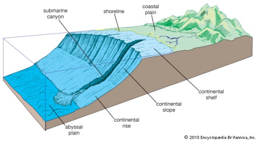
Faliki ‘o e konitineniti – ‘Oku ne fakamatala’I ‘a hono pule’I faka-Tu’I ‘o e faliki pea mo e kelekele ‘o e ‘elia ‘o e ‘oseni ‘o a’u ki he kilomita ‘e 370 mei he fonua.
Proclamation Boundary – a sovereign declared ocean boundary covering approximately 395,000 kilometres squared over the 4 island groups
Ngaahi ngatangata’anga kuo fakaha –ko ha ngata’anga ‘i ‘oseni kuo fakaha kuo pule’i ‘oku ne kapui ha ‘elia faka-fuofua ki he kilomita ‘e 395,000 sikuea ‘i he kotoa ‘o e ngaahi motu ‘e fa.

Exclusive Economic Area (EEZ) – 200 nautical miles or 370 kilometres from the nearest land covering an estimated ocean area of 700,000 km2.
‘Elia tu’umalie faka-‘ekonimika ‘o e fonua (EEZ)– ‘oku maile tahi ‘e 200 pe ko e kilomita ‘e 370 mei he fonua ofi taha ‘a ia ‘oku ne kapui e ‘elia ‘o e ‘oseni ‘oku fakafuofua ki he kilomita sikuea ‘e 7000,000.
These ocean areas define where habitats lay, species interact and migrate and where varying commercial and subsistence activities are conducted.
Ko e ngaahi konga tahi ko’eni ‘oku ne fakamatala’I e feitu’u ‘oku ‘I ai e ngaahi nofo’anga, felalave’I ‘a e ngaahi me’a mo’ui pea mo e feitu’u ia ‘oku nau nofo kiai pea ‘oku fakahoko ai e ngaahi ngaue faka-komesiale pea mo faka-taumu’a ki he ma’u me’atokoni mo e silini ‘a e famili
So, let us take a journey together “Beyond the Reef”…….
Koia ai tuku mu’a ketau fononga faka-taha pe pea mo e “Mama’o atu ‘I he Hakau”……
This programme supports the National Marine Spatial Planning Project.

Leave a comment